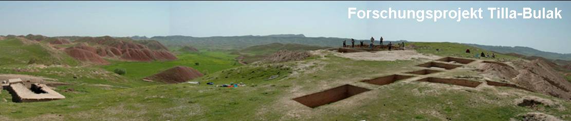
Campaign 2007
The campaign of 2007 lasted from the March 20 until April 12. The aims of our four-week venture were to test the possibilities of
carrying out our research design as well as to provide a logistic basis for such a medium-term commitment. Chronological and
stratigraphical questions, as well as the extent of the settlement and the structure of the architectural features were of prime interest.
opened just north of the top of the hill. In these trenches we only excavated the last preserved building phase. This exposure was certainly
not sufficient to gain a good idea of architecture, but we did determine that the flank of the hill formed the boundary of the preserved
settlement remains, and gained an idea of the depth of cultural layers. A deep sounding reached virgin soil at a depth of 3 m below the
modern surface, cutting through at least 3 building phases.
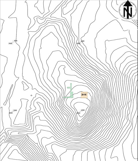
Topographical plan 2007
Campaign 2008
In the second campaign (from March 18 until April 30, 2008) we explored the entire western half of the terrace below the top the hill.
For the first time the lateral opening of mudbrick structures gave us an impression of the construction methods, the layout of the houses
and - to a limited degree - of the stratigraphy. A main building phase, datable to the late 20th or early 19th century B.C., was followed by
two phases of reconstruction, which must have followed over a very short span of time. Around 1800 B.C., Tilla Bulak must have been
abandoned.
The architecture fits well the picture we have formed from other Sapalli Culture sites: The residential units contain 2-4 rooms, each unit
containing a fireplace and chimney. The foundations of the mudbrick walls consist of river pebbles, and the walls were thinly plastered,
the floors were composed simply of compacted earth, probably covered by mats in antiquity.
On the western edge of the hill a kitchen area was discovered with two bread ovens (tannur), which offered excellent conditions of
preservation for the wheat grains ultimately processed here. Also, on the west slope we found evidence for terracing. An extremely thick
mudbrick wall in the centre of our trenches pointed to the existence of a central building.
us the hoped-for clues as to the Bronze Age architecture, but several magnetic anomalies to the north of our trenches turned out to
belong to a trench filled with ashy material, cutting off the hill from the land to the north-west, from where it is most easily accessed.
Topographical plan 2008
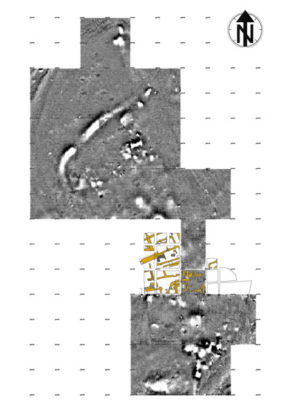
Geophysics
Campaign 2009
The third campaign lasted from March 23 until May 26, 2009. Our trenches were expanded towards the hilltop in search of the
settlements core, but we also put soundings towards the trench in the northwest to finally determine the boundary of the settlement
in this direction. The steep flanks on the eastern, southern and western sides certainly mark the limits of what is left of the Bronze Age
site today.
As expected, the architecture continued almost to the ditch discovered in the previous year. A repeat sounding of the ditch again yielded
exclusively Bronze Age material. Since the sides of the trench showed no traces of modern machinery, we are confident that we are
indeed dealing with the settlement's boundary. The settled area then adds up to some3 ha .
Our trenches in the central area gave us further clues as to the settlement structure. A building situated on top of the hill, of which we only
managed to excavate parts of the facade, was the terminal of a winding alley passing through the entire village up the slope. It was this
alley which gave direct access to the residential units.
Around the central building our finds became richer: seals, antler axes, lapis lazuli beads and bronze needles are artefact categories
found here for the first time, and point to the outstanding position of the inhabitants of this part of the site, or to the importance of the
actions carried out inside.
Just north of the central building our trenches reached natural ground. Traces of burning suggest, that a previously unnoticed fire must
have destroyed several buildings pre-dating our ‘main construction phase’, thus pushing the age of our site back a few more years.
The third campaign lasted from March 23 until May 26, 2009. Our trenches were expanded towards the hilltop in search of the
settlements core, but we also put soundings towards the trench in the northwest to finally determine the boundary of the settlement
in this direction. The steep flanks on the eastern, southern and western sides certainly mark the limits of what is left of the Bronze Age
site today.
As expected, the architecture continued almost to the ditch discovered in the previous year. A repeat sounding of the ditch again yielded
exclusively Bronze Age material. Since the sides of the trench showed no traces of modern machinery, we are confident that we are
indeed dealing with the settlement's boundary. The settled area then adds up to some
Our trenches in the central area gave us further clues as to the settlement structure. A building situated on top of the hill, of which we only
managed to excavate parts of the facade, was the terminal of a winding alley passing through the entire village up the slope. It was this
alley which gave direct access to the residential units.
Around the central building our finds became richer: seals, antler axes, lapis lazuli beads and bronze needles are artefact categories
found here for the first time, and point to the outstanding position of the inhabitants of this part of the site, or to the importance of the
actions carried out inside.
Just north of the central building our trenches reached natural ground. Traces of burning suggest, that a previously unnoticed fire must
have destroyed several buildings pre-dating our ‘main construction phase’, thus pushing the age of our site back a few more years.
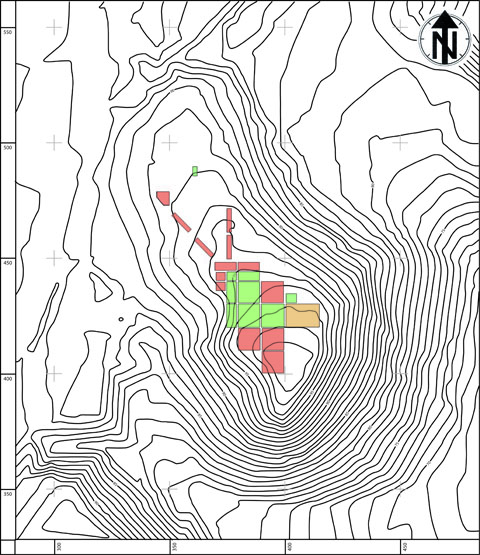
Topographical plan 2009